- News
- Reviews
- Bikes
- Accessories
- Accessories - misc
- Computer mounts
- Bags
- Bar ends
- Bike bags & cases
- Bottle cages
- Bottles
- Cameras
- Car racks
- Child seats
- Computers
- Glasses
- GPS units
- Helmets
- Lights - front
- Lights - rear
- Lights - sets
- Locks
- Mirrors
- Mudguards
- Racks
- Pumps & CO2 inflators
- Puncture kits
- Reflectives
- Smart watches
- Stands and racks
- Trailers
- Clothing
- Components
- Bar tape & grips
- Bottom brackets
- Brake & gear cables
- Brake & STI levers
- Brake pads & spares
- Brakes
- Cassettes & freewheels
- Chains
- Chainsets & chainrings
- Derailleurs - front
- Derailleurs - rear
- Forks
- Gear levers & shifters
- Groupsets
- Handlebars & extensions
- Headsets
- Hubs
- Inner tubes
- Pedals
- Quick releases & skewers
- Saddles
- Seatposts
- Stems
- Wheels
- Tyres
- Health, fitness and nutrition
- Tools and workshop
- Miscellaneous
- Tubeless valves
- Buyers Guides
- Features
- Forum
- Recommends
- Podcast
news
"Peak UK nonsense": Disbelief from cyclists and walkers at "utterly bizarre" barriers and signage installed on popular route controversially closed by council; Pro cycling's next noughties-born superstar? + more on the live blog
SUMMARY
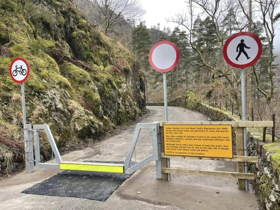 Thirlmere Reservoir signs and barriers (Philip Humphries/Facebook)
17 January 2024, 09:02
"Peak UK nonsense": Disbelief from cyclists and walkers at "utterly bizarre" barriers and signage installed on popular route controversially closed by council
Before we get stuck into this one, some context...
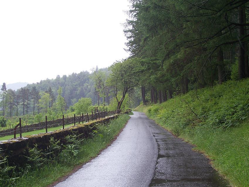
This is the popular road that runs along the western shore of Thirlmere reservoir in the Lake District. It is a "key part" of the National Cycling Network and, in Cycling UK's campaign on the matter, is described as "one of the only safe road cycling routes" towards Keswick. If this route were to disappear then vulnerable road users would be forced to use a busy A-road "hemmed in by walls with fast flowing traffic and heavy goods vehicles" as the "only alternative".
Unfortunately the quiet and picturesque waterside route was closed, at first temporarily, for two years due to storm damage. However, in the autumn, Cumberland Council proposed a Traffic Regulation Order (TRO) to close the road to all traffic, including cyclists and pedestrians.
Despite calls from many, including Cycling UK and the more than 1,000 cyclists and walkers who ignored the closure to protest the proposed closure, it was approved in November, which leaves us here today. Introducing your new Thirlmere reservoir barriers and signage...
Yes, this is the route now closed to cyclists and pedestrians, but where horse riding is allowed, hence the barrier design.
Needless to say there has been a fair bit of reaction to this...
Richard Brown: "I don't understand why all traffic apart from horse riding. Surely the risk is even greater being on a horse than being in a vehicle if there is falling debris."
Simon Douglas: "Peak UK nonsense. There will be nothing that a weekend of work won't fix and they'll spend more adding barriers over the years to stop people walking along the road than they would on just fixing it."
Merton Cycling Campaign: "The insanity (for cyclists) is the alternative route — the A591 — is FAR more dangerous. As a cyclist you cannot leave decisions about risk to organisations who don't understand or care about cycling."
Paul: "An absolutely bizarre option."
Duncan O'Sullivan: "Just fix the damn road already."
Neil Evans: "What in the hellscape is this nonsense?"
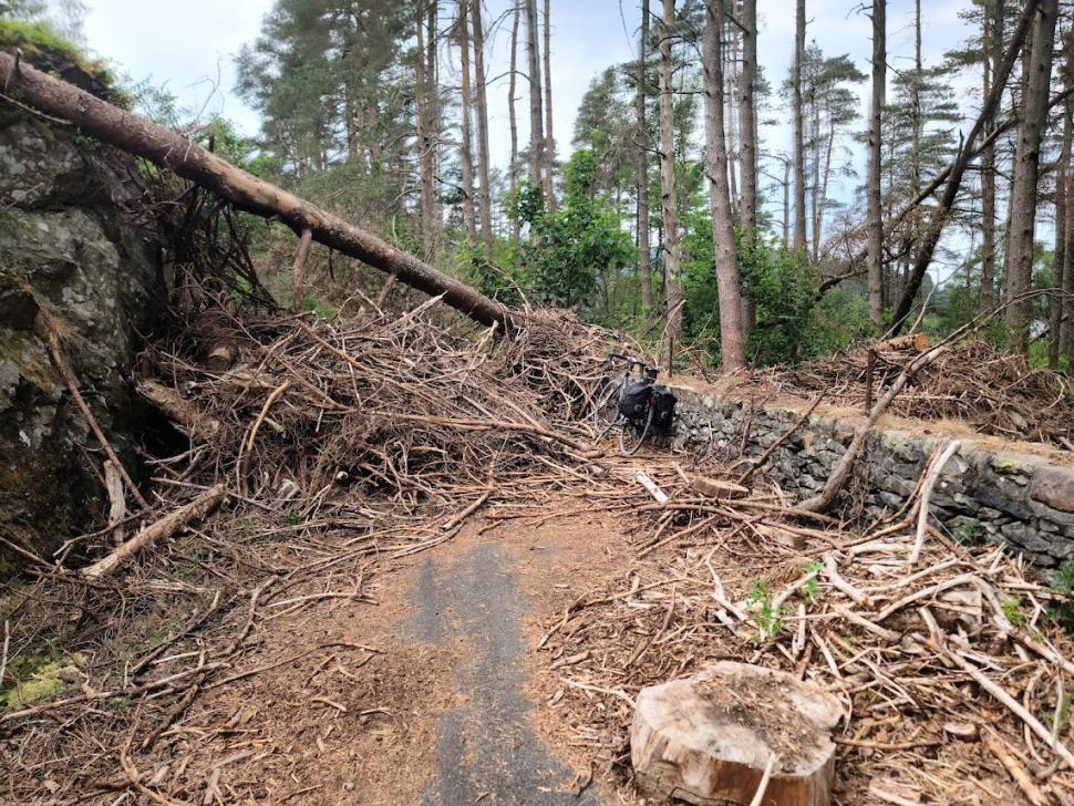
During the campaign, road.cc reader Dave got in touch to say he had cautiously avoided the previous construction site-style barriers to ride through during a summer bikepacking trip and took the picture below...
In fairness, a quite considerable amount of damage, as noted in his report, however: "There was an obvious route through and evidence of plenty of use [...] It seemed clear to me, and the other cyclist I met, that: there has been a totally unnecessary delay on dealing with this route. If it had been important for motorised traffic it would have been done very quickly."
The official line was there is a risk of falling rocks, however as Cycling UK pointed out, that while public safety is most important and falling rocks are an "obvious hazard" there "are plenty of roads around the country where falling rocks remain a risk without resulting in the extreme solution of permanent closure", not least on... the A591 on the opposite shore...
A glimmer of hope?
The road is owned by United Utilities, Cycling UK calling upon the water company to make the necessary repairs and that it should be fined if it failed to do so, and that such works could be carried out under a Temporary Traffic Regulation Order (TRO).
It is the company's responsibility, as local historian Ian Hall pointed out during the campaign, the 1879 Manchester Corporation Waterworks Act entitled the corporation to dam the lake at Thirlmere, thus creating a reservoir to pump water to Manchester. But crucially, under the act the company would be required to build and maintain a road for public use, a route that "shall be maintained by and at the cost of the corporation forever" (not until some trees fall down and you can't be bothered).
A United Utilities statement released on January 12 said:
A section of the West Road at Thirlmere is currently closed beneath Rough Crag for safety reasons. We’re currently working on a project to make the Crag safe so that the road can be reopened again as soon as possible.
A glimmer of hope? I'm sure many will want to see action before believing words...
17 January 2024, 16:48
Your thoughts on Thirlmere reservoir's latest addition... some very strange barriers
You've been filling the comments section with thoughts on this... (what's the best way to describe it?)... bizarre (being kind)... face-palmingly baffling (being less so)... barrier. Let's get stuck in...
Benthic: "In a prominent display of ignorance, they have erected a 'no cycling' sign in addition to the 'no vehicles' sign."
mctrials23: "Luckily as a cyclist that barrier looks like a lovely little bunny hop." Too dangerous, I'm afraid... now get back on that fast, busy A-road...
I think Muddy Ford gets comment of the day however...
"Obviously someone key to the decision is an equestrian. They need to get off their high horse and allow the commoners access to what they were legally entitled to do."
Cue the puns...
hawkinspeter: "Has the route been closed furlong? Back in the day, it used to be that motor cars were only for the wealthy and horses were for the poor people, yet now it's only the wealthy that have horses and cars are for the poor. My, how the stables have turned."
Steve K: "Is it a mane road?"
And plenty more after that worth a chuckle. On a (marginally) more serious note...
Creakingcrank: "Somebody should talk to the horses, to find out why their lobbying for access was successful while the cyclists and pedestrians failed."
Which would mean of course, as pointed out by the little onion, getting the answer straight from the horse's mouth... our work here is done...
17 January 2024, 16:34
Water company slammed after "absolutely vile" sewage spill on popular cycle path used by schoolchildren
*Bracing ourselves for a shit-tonne of puns*
17 January 2024, 15:04
"We don't doubt this letter will get criticism... We're human, we use our roads too and we want to sort this": Council pens open letter apologising for potholes
Derbyshire County Council has published an open letter to residents on Derby Live, apologising for the deteriorating state of the county's roads and pledging to tackle the issue:
Dear residents
On seeing this, we can hear the immediate response: don't write about it, just fill them! We do agree but we also wanted to acknowledge the problem.
We're stating the obvious to say there's been a massive increase in potholes to what we would usually see. We’re sorry for this. Whilst we always prepare for winter, the last few months really have thrown exceptional things at us. Many communities sadly are still dealing with the destruction of October and Babet's floods (with a month of rain in a single day), November's freeze and snow, and December's double the usual rainfall. You're right though when you say this recent damage isn't the only problem: this has been decades in the making with ageing highways and reducing investment comparatively.
But we're not going to fluff or filibuster with reams of stats or politics on what we're facing. We're filling hundreds of potholes each day and have extra teams on. It doesn't matter though how many potholes we're filling if the one outside your house or on your journey is still there. You, rightly, don't care about the 90,000 we filled last year, just the ones that are there now. We're also not doing comparisons with other counties. What matters is Derbyshire.
So, we're further bumping up resources to deal with the current backlog and changing from how we usually do things to focus on wider fixes where we can. We've also started a resurfacing patch programme of an extra 250 sites where we have pothole hotspots.
We'll post further updates over the next few weeks on this but, crucially, we want you to see it on the roads in action. We know that's what will make the difference.
Just to touch on a few further points, we can't always resurface every road immediately. All the budget and resources still wouldn't make that possible given how far we cover.
Sometimes the weather or underlying road problems also means a repair won't last. So we have to do temporary repairs to try to make things safe. But we do try to do permanent repairs or resurfacing where we can. Likewise, we're reviewing the materials and methods we use so we can make sure we're using the most efficient and longest lasting solutions.
Many also ask why one road has received works over another which looks worse. We sometimes have to intervene at the point we do so it protects and prolongs the life of the road at a lower cost. This then means we can do more and focus on more places.
We’re also making the case nationally for more investment — this is starting to filter through, which is what means we can do the above, but we will keep working together with others on this.
As a final but no less important note, we're seeing an increase in abuse towards our staff who are out working on the network. We understand the frustration, and share it, but hope people don't take it out on those teams. In many cases they're working round the clock in often rubbish weather. Many are stepping into roles they don't usually do to help. They're doing the best they can so, genuinely, thank you to them.
We don’t doubt this letter will get criticism. It probably would've been easier not to do it when we read the comments back. But please take this for what it is: acknowledging the challenges and problems, and being open in what we're doing. We're human, we use our roads too and we want to sort this.
We'll be out too with the teams when we can. We know actions speak louder than words so please be assured that’s what we’re doing.
17 January 2024, 12:49
17 January 2024, 14:43
Tadej Pogačar, Jonas Vingeagaard and Primož Roglič top the charts for cycling's highest-paid riders
Tadej Pogačar is the highest-paid rider in the men's WorldTour, a new report published in La Gazzetta dello Sport has suggested. The Slovenian will earn €6 million this year, compatriot Primož Roglič's transfer to Bora-Hansgrohe reportedly seeing him jump to second in the earnings list on €4.5 million per year, while Jonas Vingegaard is third on €4 million.
Away from the Grand Tour big hitters, the Italian newspaper reports Mathieu van der Poel is also on €4 million a year, while Wout van Aert will be paid an estimated €3.5 million for his 2024 efforts.
[Alex Broadway/SWpix.com]
The top ten is rounded out by Remco Evenepoel (€2.8 million), British duo Tom Pidcock and Adam Yates (€2.7 million), and Egan Bernal and Carlos Rodriguez (€2.5 million). This does not include the commercial deals enjoyed by the aforementioned riders, so in reality the figures will be higher. Not bad... especially if you live in Andorra or Monaco...
"No athlete in my career has had such a strong appeal to brands," Pogačar's agent Alex Carera said. "In cycling, Pogačar can be seen as the most universal, the most versatile, the one with the greatest communicative reach."
17 January 2024, 13:13
"He drove towards me at speed, then shouted 'b***h' in my face": Nine out of ten women face abuse while cycling, shocking new survey finds
17 January 2024, 12:28
"Not stopping after a collision seems to be almost normalised": Warning hit-and-run collision numbers at record high
The number of hit-and-run collisions in London has hit a record high, with a London Assembly member who carried out research on the issue concluding that the offence has been "almost normalised".
Caroline Russell was speaking to Ross Lydall of the Evening Standard, her research looking into the fact that there were 7,708 hit-and-run incidents recorded in 2021, the most on record for a year where data is available.
That is up 14 per cent on the 7,079 recorded in 2020, with 761 people seriously injured and 12 killed in hit-and-runs in 2021. This compared with 682 serious injuries and 14 fatalities in 2020. And while the shorter-term year-to-year statistics may also be impacted by Covid lockdowns, Russell explained that in the long-term the number of casualties in hit-and-runs in London had doubled since 2009.
The number of cyclists injured in London by hit-and-run drivers in 2021 was 1,859, with 1,327 pedestrians injured in incidents too.
"This apparent increase in irresponsible and dangerous driving on our roads is worrying," she said. "In 2021 there were nearly two-and-a-half times as many hit-and-run casualties on London's roads as there were in 2009. Not stopping after a collision seems to be almost normalised and the people that do it appear not to care about their victims or to fear any legal consequences."
The campaigner and Green Party London Assembly member has called on the city's mayor Sadiq Khan to establish an action plan to reduce such offences as part of the wider Vision Zero project.
17 January 2024, 11:38
Important news in The Telegraph: How to cycle to work — without becoming a cyclist
"How to cycle to work - without becoming a cyclist". 🤦♂️
This just goes to show why we need to adopt the Dutch term fiets/fietser. Clearly the right wing have made a name for someone who rides toxic and now they're realising the issue with that...https://t.co/4fhVuqBWjU
— Cargo Bike Ben (@cargobikeben) January 17, 2024
Interestingly this was promptly changed to... 'How to start cycling to work – without completely hating it'.
17 January 2024, 10:29
Scathing select committee report finds "not enough" communication of Highway Code changes and Department for Transport "not on track" to meet active travel goals
If you missed our story on the Public Accounts Committee's report on the Department for Transport's work on active travel here's your bullet point summary:
- Not on track to meet its active travel targets by 2025
- Not ensured active travel schemes are sufficiently joined-up with wider transport infrastructure
- Failed to communicate effectively with the public to help tackle perceptions that active travel is unsafe or to encourage more people to take part
- Is holding back local authorities from delivering on projects due to "considerable uncertainty" in funding
Yep, not the most positive appraisal...
17 January 2024, 10:05
Pro cycling's next noughties-born superstar?
With 1km to go Isaac del Toro makes a final attack, and takes out the Men’s efex Stage 2 for UAE Team Emirates 🥇@efex_IT | @Santosltd | #TourDownUnder
📺 Stream the race now on 7plus: https://t.co/k2Exq3FDwl pic.twitter.com/LwZYq1NCcS
— Santos Tour Down Under 🚴🚴♀️ (@tourdownunder) January 17, 2024
UAE Team Emirates might just have another special young talent on their hands. Clearly Tadej Pogačar and Juan Ayuso are getting on a bit, so step up Isaac Del Toro from Mexico. Date of birth? Are you ready for this? Brace yourselves? 27 November... 2003!?
The 20-year-old won Tour de l'Avenir, including the Col de la Loze stage, the race that is essentially the 'baby Tour de France' and that has been won by riders such as teammate Pogačar, Egan Bernal, Miguel Ángel López, David Gaudu, Cian Uijtdebroeks and other notable names in recent times. In short, win that and you're more than on the right track...
Well, now he's arrived in the big leagues, winning the second stage of the Tour Down Under with a monstrous attack with a kilometre to go to hold off the rest of the bunch and take his first professional win (on only his third day in the peloton). Isaac Del Toro. Remember the name.
17 January 2024, 10:01
How does a product recall work in the bike industry?
Dan is the road.cc news editor and joined in 2020 having previously written about nearly every other sport under the sun for the Express, and the weird and wonderful world of non-league football for The Non-League Paper. Dan has been at road.cc for four years and mainly writes news and tech articles as well as the occasional feature. He has hopefully kept you entertained on the live blog too.
Never fast enough to take things on the bike too seriously, when he's not working you'll find him exploring the south of England by two wheels at a leisurely weekend pace, or enjoying his favourite Scottish roads when visiting family. Sometimes he'll even load up the bags and ride up the whole way, he's a bit strange like that.
Add new comment
57 comments

Gambatte
|
1 year ago
3 likes
"We’re currently working on a project to make the Crag safe so that the road can be reopened again as soon as possible"
Yeah
One of the same companies that have taken our money to treat sewage and then illegally dumped it.
I can't think of many I would trust less, apart from maybe a politician.
hawkinspeter
|
1 year ago
13 likes
"Not stopping after a collision seems to be almost normalised"
That's due to the perverse incentives. If you fail to stop, then any subsequent penalty is unlikely to be any harsher, yet there's a chance that you'll not be discovered. Also, if you have any alcohol or banned substances in your system, then you can claim that you were shaken up by the collision and had a drink/smoke/snort to settle your nerves, but you were clean at the time.
I think leaving the scene of a serious collision without administering aid (or at least phoning for an ambulance or checking that someone is assisting) should be grounds for a lifetime driving ban and a prison term.
For less serious collisions, leaving the scene should be treated more harshly than being under the influence of alcohol - just to ensure that there's an incentive for drivers to act more humanely.

Leaving the scene of any collision should be an automatic custodial sentence. If you don't stop, you don't know whether it is serious or not.
Yes, but if you know that you've just clipped an inanimate object then different rules should apply. If however you think you clipped a mirror but instead hit a cyclist, then the full penalty should apply because the driving was bad enough that they didn't even know what they hit.

brooksby
|
1 year ago
5 likes
"Not stopping after a collision seems to be almost normalised"
This morning I was riding into work and overtaking a long queue of traffic approaching the clifton suspension bridge. As I approached a section where there were parked cars on my right, I moved into a gap in the queue as I could see oncoming traffic. As the oncoming cars passed by me I heard this massive <bang!> and looked over my shoulder to see the wing door side mirror of one of the parked cars hanging off. Nobody stopped to check what they'd hit ![]()


Hirsute
|
1 year ago
4 likes
more strange signs
https://www.bbc.co.uk/news/uk-england-york-north-yorkshire-67996335
I think it's a good idea to put unusual words onto non-critical signs like that as it gets people to expand their vocabulary and also makes the sign much more memorable if you've had to look up a word. It's a shame that "Exercise Obtundity" is the name of the police operation rather than being an instruction.


thehill
|
1 year ago
6 likes
having zoomed in and read the sign, I can see they have rolled out the "will be prosecuted" chestnut
"Any other modes of transport found to be using this route illegally (walkers, cyclists and any motorised vehicles) will be prosecuted."
Not look at the wording of the ??law?? but wondering if this is the same as all the private property signs that talk bullshit about prosecuting trespassers when in fact regular trespass is a civil matter, not a criminal matter.
For it to be valid would it not need to specify what the potential punishment/fine would be, or does that go to prove that its bullshit and trying to scare people away.
Thinking back to the BlackBeltBarrister's video about the company threatening to sue a cyclist for trademark infringement - would it be possible to get an injunction against the sign placer for threatening legal action or would the sign have to be targetting a specific person?


I'm not a lawyer, but my understanding of the legal status is:
The road remains a "road" and therefore subject to laws controlling use of roads. It has not reverted to just being "land" (to which access may be the civil tort of trespass but not a criminal offence).
The Road Traffic Regulation Act allows the relevant Authority to create "Traffic Regulation Orders" which apply to "roads" (defined as "any length of highway or of any other road to which the public has access, and includes bridges over which a road passes"). In particular, Section 2 spells out what restrictions the Authority is permitted to apply. These include prohibiting access to vehicles (including bikes) and prohibiting access to pedestrians. Section 2 does not mention horses (either by deliberate or inadvertent omission).
It is an offence to contravene a Traffic Regulation Order.
https://www.legislation.gov.uk/ukpga/1984/27/section/2
This would appear to create a somewhat tortuous result that it is a "road" because the public have access to it, and therefore the Authority has the power to prohibit public access to it. I'm not entirely clear how this legislation interacts with other legislation that provides for Public Rights of Way such as the Wildlife and Countryside Act 1981 or Countryside Act 1968.

https://www.bbc.co.uk/news/uk-england-cumbria-67981472
"A footpath near a Lake District beauty spot that was damaged in a storm has reopened to walkers.
United Utilities opened the footpath on Friday, while a tarmac road alongside also reopened for horses and riders."
https://www.ukclimbing.com/forums/crag_access/thirlmere_access_update-76...
"The use of barriers in support of the restrictions is permitted by Section 92 of the 1984 Road Traffic Regulation Act, however horse riders will be able to pass if they so choose. The Council will ensure that signage is erected to make horse riders aware of the danger together with signage that the road is closed to vehicles (including pedal cycles) and pedestrians."


mitsky
|
1 year ago
2 likes
Reason #42 cyclists don't use a cycle lane...
"Old Norwich Road is a dedicated bus route, and the council said the dumped sugar beet was blocking the cycleway lane."


Most interest Suffolk highways have ever taken to a blocked cycleway, we've got roads still flooded from October, potholes like this https://www.eadt.co.uk/news/24044689.huge-pothole-ipswich-road-debenham-... and they get in a right tizz about some sugar beet left on side of the road on a near traffic free dead end route ?
The road is essentially an LTN, to stop motorists rat running A14 congestion, with only buses allowed as motorised access thru, consequently very few drive along it, and why it ended up as a cycle route.
The bit they're talking about is here
https://maps.app.goo.gl/K1M14oWRNrB6wWp87
no one I know locally rides the painted bit of marked cycleway, I think Timmy Mallet did on his round UK ride but mentioned it was odd, because it forces you off route onto a surface that's probably not been touched in the 40 years or so the road stopped being used properly, the actual road to the right is fine has plenty of room as there's next to no traffic and the cycleway is one way only anyway.


Obviously someone key to the decision is an equestrian. They need to get off their high horse and allow the commoners access to what they were legally entitled to do.
Has the route been closed furlong?
Back in the day, it used to be that motor cars were only for the wealthy and horses were for the poor people, yet now it's only the wealthy that have horses and cars are for the poor. My, how the stables have turned

Pages
Latest Comments
- hawkinspeter 3 min 53 sec ago
I interpreted it as "I'm now so powerful that I don't even need to hide my actual politics". Similar to Trump's comment about how he could murder...
- hawkinspeter 8 min 21 sec ago
I think there's a difference between trying to drag him into everything (which I don't tend to do) and ignoring that a presidential inauguration...
- GMBasix 10 min 12 sec ago
[certain retailer] proudly delivers another bike
- brooksby 20 min 8 sec ago
All those photos of Concerned Locals™ - surely a good moment for local cyclists to ride past, ideally in primary position?
- brooksby 22 min 26 sec ago
Given that it is trying so hard to be really very modern and hi-tech, I'm sure that there would have been a better way of sorting out braking on...
- mdavidford 1 hour 1 min ago
I would assume there's some kind of transmission in this bit. Don't know about a 'clunk' though - if it's capable of mimicking all kinds of gear...
- HollisJ 1 hour 34 min ago
Weird. I went there a few weeks ago and all I saw was a cycle lane and plenty of free parking provision next to it, no keeerrraazy wiggly lines....
- chrisonabike 3 hours 11 min ago
I suspect a different poster - our consistently unlucky (yet somehow surviving) wheelchair user never had anything good to say about cyclists!
- Rendel Harris 3 hours 48 min ago
That's a very good point, I remember once speaking to somebody who had volunteered in Gaza as a medic who said that the vast majority of the...
- OldRidgeback 4 hours 19 min ago
It isn't the first time BC has avoided sending riders to events, even when there have been riders with potential.
