- News
- Reviews
- Bikes
- Components
- Bar tape & grips
- Bottom brackets
- Brake & gear cables
- Brake & STI levers
- Brake pads & spares
- Brakes
- Cassettes & freewheels
- Chains
- Chainsets & chainrings
- Derailleurs - front
- Derailleurs - rear
- Forks
- Gear levers & shifters
- Groupsets
- Handlebars & extensions
- Headsets
- Hubs
- Inner tubes
- Pedals
- Quick releases & skewers
- Saddles
- Seatposts
- Stems
- Wheels
- Tyres
- Tubeless valves
- Accessories
- Accessories - misc
- Computer mounts
- Bags
- Bar ends
- Bike bags & cases
- Bottle cages
- Bottles
- Cameras
- Car racks
- Child seats
- Computers
- Glasses
- GPS units
- Helmets
- Lights - front
- Lights - rear
- Lights - sets
- Locks
- Mirrors
- Mudguards
- Racks
- Pumps & CO2 inflators
- Puncture kits
- Reflectives
- Smart watches
- Stands and racks
- Trailers
- Clothing
- Health, fitness and nutrition
- Tools and workshop
- Miscellaneous
- Buyers Guides
- Features
- Forum
- Recommends
- Podcast
news
 Google Maps July 2022 update
Google Maps makes major update to cycling navigation
Google Maps has made a major update to its cycling navigation capabilities, including which route options will see riders encounter heavy traffic, as well as highlighting ones where they will find greater provision of cycling infrastructure.
Highlighting that “over the past few months, cycling has increased by more than 40 per cent worldwide,” Google says on its Blog that its new route information means that cyclists will “soon be able to easily compare bike routes and see even more granular details (when this data is available) to prepare for the ride ahead.”
Cycling directions, giving route options and estimated timings as well as a comparison of elevation profiles have been a feature of Google Maps for a number of years now, but the internet giant says that the new features mean that “In addition to seeing the elevation along your route, you’ll also know if you’ll encounter heavy car traffic, stairs or steep hills.
“You’ll also be able to get a highly detailed breakdown of the route itself so you can know at a glance what type of road you’ll be biking on – like a major road vs. a local street. Gone are the days of unknowingly pedalling up a strenuous hill or on a route with more car traffic than you’re comfortable with.”
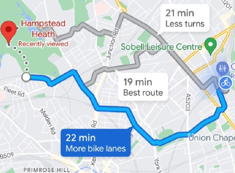
Here’s how it would look on your phone, with route options provided for a journey from just south of Arsenal FC’s Emirates Stadium to Hampstead Heath (if you’re finding that difficult to view, take a look at it on the Google Blog, which also has details of other non-cycling features being added to Google Maps).
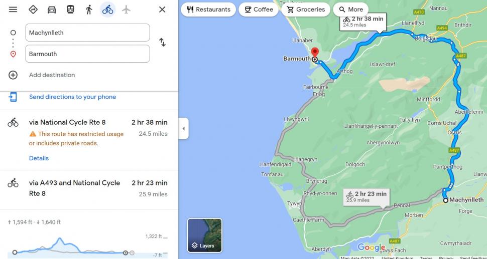
As mentioned above, providing alternative routes and displaying their profiles – with altitude of start and finish points, plus how much climbing and descending is involved in each shown in feet – has been a Google Maps feature for a number of years now.
> Google Maps unveil new ‘lite navigation’ system specifically for cyclists
Here’s an example of existing Google Maps cycle routing from Wales for a trip from Machynlleth to Barmouth, following two route options available on National Cycle Network Route 8, one inland taking in a big climb as it heads through the Snowdonia National Park, the other providing a much gentler option mainly along the coast.
Latest Comments
- hawkinspeter 0 sec ago
Another vote for Bont, here. I bought a new pair of wide-fitting Bont Riot G MTB shoes this year and they're perfect.
- RobD 5 min 50 sec ago
It's a real shame, his bikes seem incredible, I've dreamt of owning one for a long time. Really sad that he's had customers let him down repeatedly...
- David9694 52 min 56 sec ago
Car smashes into wall near Exeter Cathedral...
- David9694 1 hour 2 min ago
Driver Who Broke Runner's Spine in Three Places Praised for Waiting Around Until Help Arrived
- Steve K 1 hour 39 min ago
Even if this gets to 100,000 signatures, I suspect the Petitions Committee will simply say there has already been a debate, so no need for another...
- Prosper0 9 hours 30 min ago
Just doing the Lord's work in case anyone's interested in this product. This Mucoff Pump is a £100 rebrand of an £85 Rockbros rebrand of a £60...
- mdavidford 10 hours 19 min ago
Obviously it means 'springing out of the bunch' on a critical sector. Or maybe it's referring to the time of year.
- David9694 11 hours 7 min ago
Woman taken to hospital after flipping car onto roof in Trowbridge...

Add new comment
10 comments
"Less turns" indeed. Translated to English, thats "fewer turns".
We could do with less comments like this.
Totally approve of the pedantry but might need to get an apostrophe in there to make it credible.
My biggest problem with Google maps cycling is that I'm invariably sent on rough tracks suited for a MTB. Wish they would offer alternative routes for MTB and road bikes
Yep, they don't seem to let your choose surfaces like dedicated route planners on Komodo's ot strava. Although I think you have to subscribe for that benefit on those platforms.
This. Had a near disaster down near Bordeaux a few years ago where it took me up some tracks which would have been probably ok for the most part were it not for the fact that it was raining torrentially. They certainly wouldn't have been suited to a pure road bike. One turned into deep sand crossed with brakes that just couldn't be cycled. Another was 6 inch deep mud. Pièce de resistance was when it insisted I take a right into some dense pine forest that had never seen a track of any sort. I now use either cycle.travel as somebody else has suggested, or Komoot (worth paying for the maps especially if you come across an offer) as their navigation is great
Nice to see cycle routing going more mainstream, I'll stick with the little guy for the moment though.
https://cycle.travel/
I've found this one works well, though It's a bit more leisure/family focussed than your average roadie ride it's easy to drag and change.
Has extra functionality to break long trips etc.
Is 'more bike lanes' meant to be a feature or a warning?
Hopefully they'll correct the grammar...
Here you go!
http://itre.cis.upenn.edu/~myl/languagelog/archives/003775.html